Precision Forestry
Commercial Forestry Monitoring
Precision forestry is the technical term for concise forest management techniques that make use of modern GIS software and satellite imagery technology to collect, process and present data that allows foresters and plantation owners to make informed decisions for site-specific, economic, environmental, and sustainable actions along the forestry value chain.
Introducing our Comprehensive Online Precision Forestry Monitoring Platform


Plantation & Forestry Monitoring
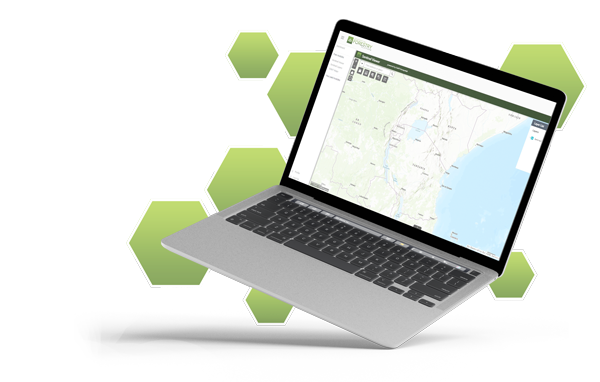
Swift Geospatial has designed and implemented an online portal capable of providing a proactive forestry monitoring solution for forestry plantations. This is achieved by using the latest high resolution multispectral satellite imagery and cloud processing technology.
The monitoring results can be generated and delivered at a frequency that suits the business operation and budget. This can be quarterly, monthly, weekly or even now daily. With dynamic cloud-based processing, our solutions can scale from one compartment to an entire plantation covering many thousands of square kilometres.
How it Works
Making use of the latest satellite and cloud technology, Swift Geospatial is able to remotely monitor forestry plantations for tree health, harvesting progress and fire break status. Satellite data is fed into our custom cloud processing engine and the results are delivered to the cloud platform in near real time. This solution offers the quickest and most cost-effective solution to monitoring forestry plantations of any size.
Plantation & Forestry Monitoring
Swift Geospatial has designed and implemented an online portal capable of providing a proactive forestry monitoring solution for forestry plantations. This is achieved by using the latest high resolution multispectral satellite imagery and cloud processing technology.
The monitoring results can be generated and delivered at a frequency that suits the business operation and budget. This can be quarterly, monthly, weekly or even now daily. With dynamic cloud-based processing, our solutions can scale from one compartment to an entire plantation covering many thousands of square kilometres.
Health
Multispectral NDVI compartment health analysis

Harvesting
Active tracking of harvesting status and progress

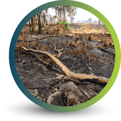
Fire Break Analysis
Status of fire break completion and Post fire damage analysis
Health
Multispectral NDVI compartment health analysis
Harvesting
Active tracking of harvesting status and progress
Fire Break Analysis
Status of fire break completion and Post fire damage analysis


The above images represent an NDVI image on the left and an RGB colour image on the right. This NDVI image represents the plantation health with dark orange showing healthy plantations and blue bare earth. The analysis through our custom models are then transformed into health status, harvesting status and fire break analysis for the forest manager to aid in tracking of the plantation and decision support
The above images represent an NDVI image on the left and an RGB colour image on the right. This NDVI image represents the plantation health with dark orange showing healthy plantations and blue bare earth. The analysis through our custom models are then transformed into health status, harvesting status and fire break analysis for the forest manager to aid in tracking of the plantation and decision support
Sign up to explore our free precision forestry monitoring modules
Explore the Forestry Platform through our complimentary free modules. Granting you access to freely available datasets providing you a with baseline overview of your forestry areas. Available data includes near-real-time satellite imagery with basic on-the-fly-analytics; administrative and a wide range of geographic datasets

Site Species Matching Tool

Sentinel Viewer

Spatial Layers

Explore our in-depth and concise precision forestry monitoring Geospatial Forestry Platform modules
Modules are individually tailored o your specific monitoring requirements. Including analytics such as satellite-based tree counts, monthly forest health and harvest analysis, forest resource mapping, post-fire analysis and more.
Site Species Matching Tool

Climate Scenarios Suitability

Deforestation Monitoring

Woodlot Mapping

Woodlot Monitoring

Inflield Stress

Satellite Imagery Request

Post Fire Analysis

Road Network Analysis

Carbon Sequestration

Tree Count

Road Network Analysis
Enjoy our latest blog posts discussing the usage of the GFP

The positive impact of precision forestry projects across the globe
Ensuring the most efficient and future-proof forestry monitoring and management processes are in place is fundamental to long-term environmental, economic and social sustainability. Using precision forestry, which focuses on integrating new technology into these processes, is the answer.

The importance of Decision Support Systems (DDS) in forestry management and planning
When it comes to forestry management and planning, the more information you have at your fingertips the better you can get a bird’s-eye view of potential risks, such as climate change and deforestation. However, sifting through this information and understanding how to use different pieces of data for actionable outcomes is even more critical. And that is where Decision Support Systems (DSS) play a vital role.

European Forestry Regulations – The Journey To A Climate-Neutral EU by 2050
According to Forest Europe, forests cover 227 million hectares of total land in Europe. Protecting them as a critical carbon sink that absorb around 10% of total EU emissions needs to be at the top of the priority list. Here are the EU regulations keeping them protected.
CONTACT US
If your business is looking to save time on monitoring your forests and plantations through a concise, online, dashboard driven all-in-one precision forestry monitoring program.
Let’s arrange your free trial today.