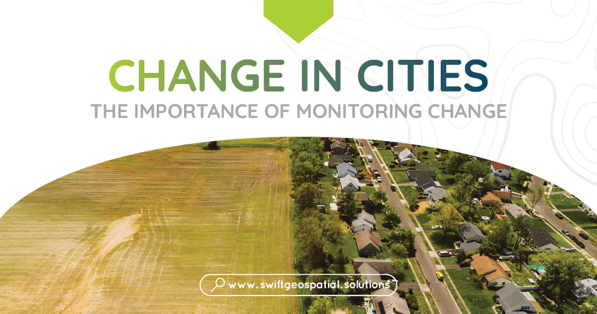
Why do we monitor changes in cities?
To put it simply, because more and more people are living in cities than ever before. What this means is that cities are growing at a rapid rate and constantly changing to accommodate their growing numbers of citizens. To manage this growth, governments and organisations must monitor change detection in cities to see what’s happening and what needs to be done to run effective systems and governance. Change detection monitoring means comparing pictures of cities taken from satellites at different times to see what has changed, like new buildings, land use changes, or changes in green areas.
One reason we monitoring change is that it helps us to see where the city is growing the fastest. By monitoring incremental changes, we can figure out where the people will need more things like housing, transportation, and water systems. This helps us to make smart decisions about where to put these things and plan for the future, making sure that inhabitants of cities have what they need.
Through GIS and satellite imagery, we are able to notice where the city is hurting the environment. As cities grow, they often destroy or change natural areas, causing more air and water pollution, soil erosion, and loss of wildlife. Change detection monitoring can help us to see where these problems are the worst, so we can do something to reduce the environmental damage of urbanization.

Why do we monitoring changes in servitude areas?
Servitude monitoring through the integration of Geographic Information Systems (GIS) and remote sensing technology offers a robust and comprehensive approach to ensuring proper land utilization and safeguarding against encroachment. By combining the power of GIS’s spatial analysis capabilities with remote sensing’s ability to capture real-time, high-resolution imagery, this approach enables authorities to closely monitor land usage patterns, detect unauthorized activities, and track any encroachments onto designated areas.
The synergy between GIS and remote sensing allows for the creation of accurate, up-to-date maps that delineate servitude boundaries and land use categories. This not only facilitates efficient planning and management but also provides a tool for rapid identification of any deviations from approved land use practices.
Timely alerts generated by remote sensing data can flag potential encroachments, enabling swift action to be taken to prevent further violations. Overall, the synergy between GIS and remote sensing presents a powerful solution to maintain the integrity of servitudes and ensure sustainable land management while proactively preventing encroachment issues.
How does servitude monitoring work? Swift Geospatial makes use of high resolution satellite imagery and GIS software to see how the land is being used and if anything has changed over a given period of time. Creating maps that showcase movement and changes allows for better decision making by those in positions of responsibility. We are able to observe and track changes in land use over time, including illegal encroachment into servitude areas.
Servitude monitoring is incredibly important for governments and organisation for planning that what happens in the area is correct under the local laws.
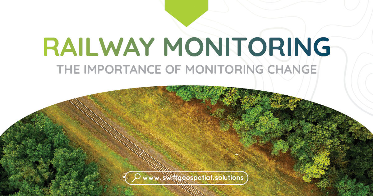
Satellite Monitoring and Railways
Do you know why satellite monitoring is a great way to monitor railways? It’s because it has many benefits, like being cheaper, more accurate, and more accessible.
One benefit of satellite monitoring is that it saves money. You don’t need to go and check the railways yourself or collect data manually. You can just use satellite images to monitor the railways from afar, which makes it more efficient and cheaper.
Another benefit of satellite monitoring is that it gives you a lot of detail and accuracy. Satellites have high-resolution cameras that can take pictures with a lot of detail and accuracy, so you can see even small changes or problems on the railway tracks. You can’t get this level of detail with other methods of monitoring.
A third benefit of satellite monitoring is that you can access it from anywhere in the world. This means that you can monitor railways in places where it’s hard or impossible to do it on the ground. This is very important in countries with big, remote railway networks, where checking them on the ground can be very time-consuming, expensive, and dangerous.
Satellite monitoring can help you with many things when it comes to railways. For example, it can help you find defects on the tracks, like misalignments or cracks. Then you can use this information to plan when and how to fix them, making sure that the railway is safe and working. Satellite monitoring can also help you find changes in the railway environment, like vegetation growth or landslides, which could affect the safety and efficiency of the railway. Then you can use this information to plan and prioritize what to do about them.
Another thing that satellite monitoring can do is to monitor train movements and predict possible delays or problems. By watching train movements, railways can make their schedules better and more efficient. They can also use this data to plan for future changes or upgrades to the railway network.
To sum up, satellite monitoring is a cheaper, more accurate, and more accessible way to monitor railways. It gives you a lot of detail and can help you find defects, environmental changes, and train movements. As satellite technology gets better, it is likely that satellite monitoring will become a more popular way to monitor railways around the world.

Monitoring pipelines using satellite imagery has become an invaluable tool for ensuring the safety and security of pipeline infrastructure. Satellite imagery is able to cover an extremely wide coverage area, capturing images of vast geographic regions including remote and inaccessible locations. This comprehensive view allows for the identification of potential issues or changes along the entire pipeline network.
Satellites imagery used in conjunction with GIS can detect changes in vegetation, land cover, ground surface, and infrastructure. Organizations can monitor vegetation encroachment, ground subsidence, land movement, leaks, or other anomalies that may pose risks to pipelines. The ability to acquire satellite imagery at regular intervals enables frequent and timely monitoring, allowing for the detection of changes in near-real-time. By comparing images taken at different times, organizations can proactively address any identified changes or disturbances, facilitating maintenance and response efforts.
One of the significant advantages of satellite imagery is its contribution to enhanced safety and security measures. By detecting potential leaks or unauthorized activities, organizations can swiftly respond to mitigate risks and prevent incidents that may have severe environmental or safety consequences. Satellite imagery aids in identifying encroachments, construction activities near pipelines, or potential security threats, allowing for timely intervention.
Satellite imagery archives also enable historical analysis of pipeline infrastructure. By accessing past imagery, organizations can evaluate long-term changes in pipeline corridors, identify patterns, and assess the effectiveness of maintenance or mitigation measures over time. This historical analysis helps in understanding the evolution of pipeline environments and supports future decision-making.
Integration of satellite imagery with Geographic Information Systems (GIS) provides a spatial context for pipeline monitoring. By combining satellite imagery with other geospatial data, such as land cover, elevation, or infrastructure layers, organizations can gain a comprehensive understanding of pipeline conditions and potential risks. GIS integration enables robust analysis, visualization, and decision support, enhancing the effectiveness of pipeline monitoring efforts.

Monitor Change In Informal Settlements
One reason why we need to monitor the changes of informal settlements is to understand the impacts of development on the people and the environment. As more people move to settlements, they need more services and infrastructure, such as housing, transportation, water, and electricity. By monitoring these changes, we can see where the needs and demands are, and how to plan and provide for them. We can also see how development affects the natural habitats and resources around the settlements, such as soil, water, wildlife, and climate.
Another reason why we need to monitor the growth of settlements to identify areas of social and economic inequality. Settlements are often poor and marginalized, and they face many challenges such as unemployment, crime, violence, and disease. By monitoring the growth of settlements, we can see where these problems are most severe, and how to address them. We can also see how to improve the quality of life and opportunities for the people living in settlements, such as by investing in education, health, and other social services.
How do we monitor the changes and growth of settlements? One way is to use satellite or aerial images that can show us the changes in urban landscapes over time. We can compare images taken at different times to see what has changed, such as new buildings, land use changes, or vegetation cover. This can give us a lot of information about the conditions and trends in settlements.
Monitoring the changes and growth of settlements is very important for South Africa. It can help us to manage the development and expansion of urban areas in a way that is sustainable and equitable. It can also help us to protect the environment and human rights of the people living in settlements. As settlements continue to grow, we need to keep an eye on them and make sure they are developed in a way that is good for everyone.