Swift Geospatial Partners With Ecosia For Pro-Active Tree Monitoring
As the world’s largest not-for-profit search engine, to date, Ecosia has planted more than 128 (and actively counting!) million trees across over 30 countries worldwide, all in the name of good-will. Headquartered in Berlin, Germany, Ecosia wants to ensure their integrity and accountability towards their users, and are therefore taking the monitoring of their trees to the next level.
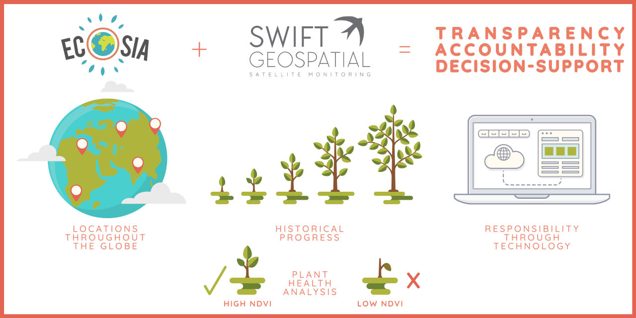
Enter their newfound partnership with Swift Geospatial: a South African satellite monitoring company that will be providing -through their affiliation with Planet– the vital on-going and near real-time information that is needed. Information such as the survival and growth rate, as well as general health of the trees that are being planted will be given on a monthly dashboard; while the 3 metre resolution imagery will provide Ecosia with unbiased verification of their work; empowering them as this decision-support tool asserts the accountability and transparency of what they aim to achieve in the world.
What is Ecosia?
With an outcome of over 128 million trees planted across over 30 countries worldwide, Ecosia (pronounced ‘Eco-sia’), is the world’s largest not-for-profit search engine. Founded by Christian Kroll in 2009, and headquartered in Berlin, Germany, the initiative uses 80% of its profits (47.1% of its income) from advertising revenue to support tree planting projects. The user-friendly home page gives an example in a nutshell: ’We use the profit we make from your searches to plant trees where they are needed most.’
How does Ecosia work?
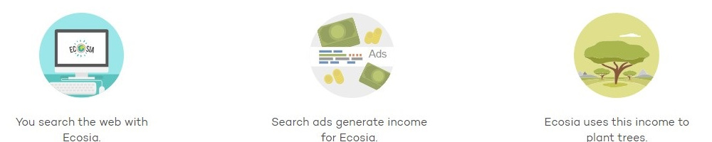
As a part of the Microsoft Search Network which includes Yahoo, AOL and DuckDuckGo, Ecosia gains access to the search algorithm that powers Bing, as well as Microsoft’s network of advertisers, in exchange for a percentage of its advertising revenue. The income is then productively used to plant trees in identified areas of need throughout the globe.
What is more; with its own solar plants, the carbon negative B Corporation has added enough clean energy to the grid in order to power all of Ecosia searches with not 100% renewable energy, but 200%. Meaning that they are not just producing enough solar energy to power data centers for all the searches with renewables, but twice as much. Making them not just carbon neutral, but carbon green. Ecosia is removing much more CO2 than they emit and is why they don’t just protect trees, but also regenerate former forests.
In 2018 Ecosia gave away its shares to the Purpose Foundation, to assure that it can never be sold and that no one -including the founder- can ever profit or receive dividends from the company. With 100% of their profits dedicated to climate action, with more than 80% financing tree-planting projects around the world
What is Swift Geospatial’s new role in this partnership?
Ecosia recently took the initiative to approach Swift Geospatial for assistance with what they had identified as a shortfall within their tree planting methodology: a satellite monitoring service. A service that is, in general, overseen by most tree planting campaigns; it was recognised that satellite monitoring would help to both validate and remotely verify that the trees that have been planted are indeed surviving and thriving. With transparency as one of Ecosia’s strongest values; this well-known initiative amongst the eco-conscious of us would not want to prematurely share promises and impacts that would never be reached, after all.
It was thus agreed that henceforth Swift Geospatial will be monitoring all of Ecosia’s planting sites in locations around the globe, as a resultant partnership is formed moving into the exciting future.

Over 128 million trees planted across over 30 countries worldwide
Worthy services that will be provided through the investment of monitoring:
Impressively high resolution daily imagery
Swift Geospatial will be providing Ecosia with monthly 3 metre resolution RGB NIR colour satellite imagery of their plantations. Accessed from their partner, Planet, who endeavour to collect the landmass of the world every single day (thereby resolving the inevitable cloud cover obstacle so common with equatorial / tropical areas through this consistent revisit rate); this will include 3 metre resolution NDVI mosaic imagery from their 4-band multispectral sensor. Through the selection of the best pixels (with each pixel representing 9 square metres); Swift Geospatial transforms the valuable data into visually consistent and scientifically accurate mosaics, built from the most recent imagery over broad areas.
(Wow. What a mouth-full… but do read on for further clarity!)
Measuring plant health through NDVI readings


The image above indicates the health of the plants of a given area: the NDVI readings that are red in colour are unhealthy plants; while the green areas are healthy plants. This is an example of how the monitoring technology used can pick up what the human eye cannot yet see- helping Ecosia to resolve any issues before they spread and it is too late.
For the layman; NDVI stands for Normalized Difference Vegetation Index, and is a measure of the state of plant health, based on how the plant reflects and absorbs light at certain frequencies; quantifying the concentrations of green leaf vegetation. Michael Breetzke, one of the company directors explains; ‘the higher the NDVI reading; the higher the chlorophyll context, which equals a thriving plant in good health. However, a low NDVI reading will quickly alert users that there is a disturbance in the health of the plants- which may be due to disease, plague, drought, etc.’
Due to the remarkably high resolution imagery provided by the Planet platform; this allows Swift to detect these NDVI values a lot sooner than other satellite services; and in turn allowing Ecosia to waste no time in ascertaining the difference they are making in their study areas. This live information will therefore allow the team at Ecosia to instantly assess the spread and impact of disease and other significant changes in the health of the trees they have planted; nipping disturbances in the proverbial bud before it is too late or costly to remedy.
What’s more, a worthy note is that the unbiased technology picks up what the human eye cannot yet see- as it is able to catch disease before it palpably spreads.
Avoiding disputes over biased photographs that planters may or may not take of the planting progress; Ecosia will also save themselves a heap of surplus funds (meaning more trees can be planted!) by sending surveyors to the site only when necessary and alerted by the up-to-date dashboards that will indicate this vital information.
Access to historical imagery

Monitoring canopy growth through time.
Through access to all historical imagery of their planting sites across the globe; Ecosia will be able to ascertain the difference their projects are making to the areas they are working on with these valuable visuals. For example; the high resolution satellite images of Burkina Faso will very tangibly show evidence of how they are making this desert fertile again as the canopy cover extends its greenery through time.
Sharing this fascinating progress with their user groups will not only provide evidence of where the funds are going; but will also inspire them to be more involved, for the longer term.
Progress reports

Responsibility Through Technology
All imagery and stats analysis will be shared through an online web-application for ease of use. Project progress such as the mean NDVI values and growth trend curves for each planting site will further equip Ecosia with vital information as to how their initiatives are progressing on a month to month, as well as a year to year basis. The resultant dashboards that will be provided will thus empower Ecosia with the data that is needed for informed decision-making into the future.
Moving forward
In short, Ecosia has taken a bold step in taking responsibility for their tree planting throughout the globe. Through the process of satellite monitoring; the search engine that plants trees now beams with transparent integrity, as they have invested in a pretty darn powerful decision-support tool. Using the incredible technology available, Ecosia has empowered itself to make proactive rather than reactive decisions.
As they rapidly become one of the biggest environmental movements in the world; Swift Geospatial believes that Ecosia’s new monitoring initiative is indeed a catalytic example to the thousands of tree planting campaigns out there- watch this space!
For more information that delves into the technicalities of what has been mentioned so far, do not miss part two of this article to follow shortly!