
How Swift Geospatial Elevates the Mining Industry with Precision Monitoring and Bespoke GIS Solutions
With our expertise in satellite imagery and remote sensing, we offer a range of services that not only streamline day-to-day mining operations but also help companies meet regulatory requirements and reduce their environmental footprint.
Categories:
Innovation , Mining , Swift News , Technology
Date Posted:
October 31, 2024
How Swift Geospatial Elevates the Mining Industry with Precision Monitoring and Bespoke GIS Solutions
The mining industry is known for its vast scale, complex logistics, and environmental challenges. As demand grows for safer, more efficient, and environmentally responsible mining practices, companies must adapt to new technologies. Swift Geospatial supports these needs with cutting-edge earth observation and satellite imagery solutions, offering tailored GIS tools to address the unique challenges of modern mining.
Using high-resolution satellite imagery and remote sensing, Swift Geospatial provides services that improve operational oversight, support regulatory compliance, and reduce environmental impact. Our expertise empowers mining companies with reliable, actionable data that drives efficiency, enhances environmental monitoring, and mitigates risks such as unauthorized encroachments or illegal mining.
Trusted Precision in Mining Operations
Accuracy is essential in mining operations, where missteps can lead to costly delays, fines, or environmental risks. Mining companies worldwide trust Swift Geospatial for real-time satellite-based monitoring solutions, providing precision that safeguards both operations and the surrounding environment. Our solutions offer a user-friendly dashboard that brings critical insights directly to mining operators, whether it’s tracking extraction progress, ensuring compliance with environmental regulations, or identifying encroachment risks.
How Our Solutions Work
Swift Geospatial specializes in procuring high-quality satellite imagery for client-defined areas of interest. Using timestamped, high-resolution imagery captured at consistent intervals, this data integrates seamlessly with our GIS remote monitoring system. Leveraging earth observation technologies and machine learning, we offer robust change detection, enabling mining operations to detect encroachments, monitor landscapes, and observe critical changes in real-time.
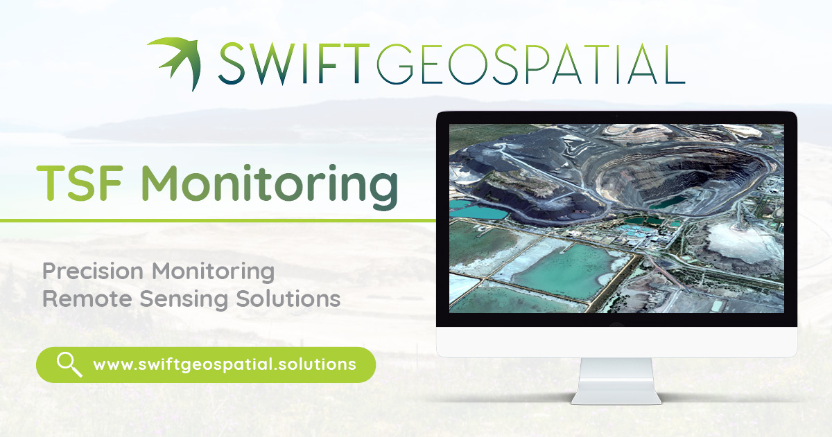
Tailings storage facility (TSF) monitoring: A top priority
One of the greatest risks in mining is the potential failure of Tailings Storage Facilities (TSFs). These massive structures hold the by-products of mining processes and must be closely monitored to prevent any structural issues that could lead to environmental disasters. Swift Geospatial offers advanced TSF monitoring services that leverage satellite imagery and geospatial data to detect early signs of instability or deformation.
Our system captures and analyzes data in real-time, allowing mine operators to stay ahead of any potential issues. By regularly monitoring TSF stability, we help mining companies mitigate risk, prevent costly incidents, and ensure the safety of their operations. With Swift Geospatial’s tools in place, operators can make informed decisions, improve site management, and maintain regulatory compliance with ease.
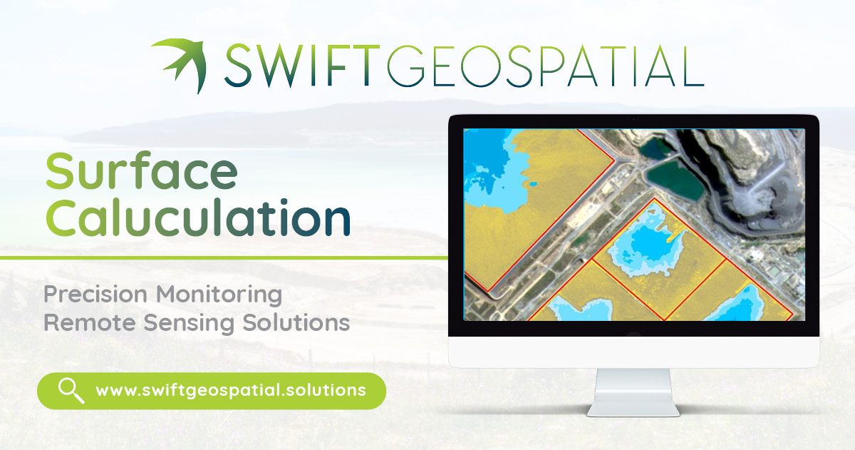
Volume Calculations: Precision in Material Management
Accurate volume calculations are critical for assessing stockpile volumes, calculating material extraction, and managing resources effectively. Traditionally, this process has been time-consuming and prone to human error. With Swift Geospatial’s advanced geospatial analytics, mining operators can calculate material volumes with unmatched accuracy and speed.
Using satellite imagery and Photogrammetry, we offer a high-precision, cost-effective solution that eliminates the need for manual measurements and reduces the margin of error. This ensures that mining companies can streamline their operations, optimize their resources, and confidently report on material volumes for planning and auditing purposes.

Comprehensive Environmental Monitoring
Mining has always had a significant environmental impact, making environmental monitoring a crucial part of every operation. Today, more than ever, mining companies must stay on top of environmental regulations, particularly as public scrutiny and government oversight intensify. At Swift Geospatial, we provide a suite of environmental monitoring services designed to help mining companies track and minimize their impact on the surrounding ecosystems.
Using satellite imagery and remote sensing, we monitor vegetation growth, track land-use changes, and detect any encroachment that may occur near mining sites. By continuously analyzing environmental data, our clients can ensure compliance with environmental laws, address issues before they escalate, and maintain a positive relationship with regulators and local communities. Our services also open up opportunities to rehabilitate mines using archived imagery as a reference point for what the area of interest could be restored to.

Monitoring Encroachment and Unauthorized Activity
In addition to environmental monitoring, Swift Geospatial helps mining companies stay vigilant about encroachment and unauthorized activities on their land. By using satellite imagery to track land use in real time, we provide critical insights that help operators identify and address potential encroachment threats before they become serious issues. Whether it’s monitoring buffer zones or detecting illegal mining activities, our services ensure that your assets remain secure.

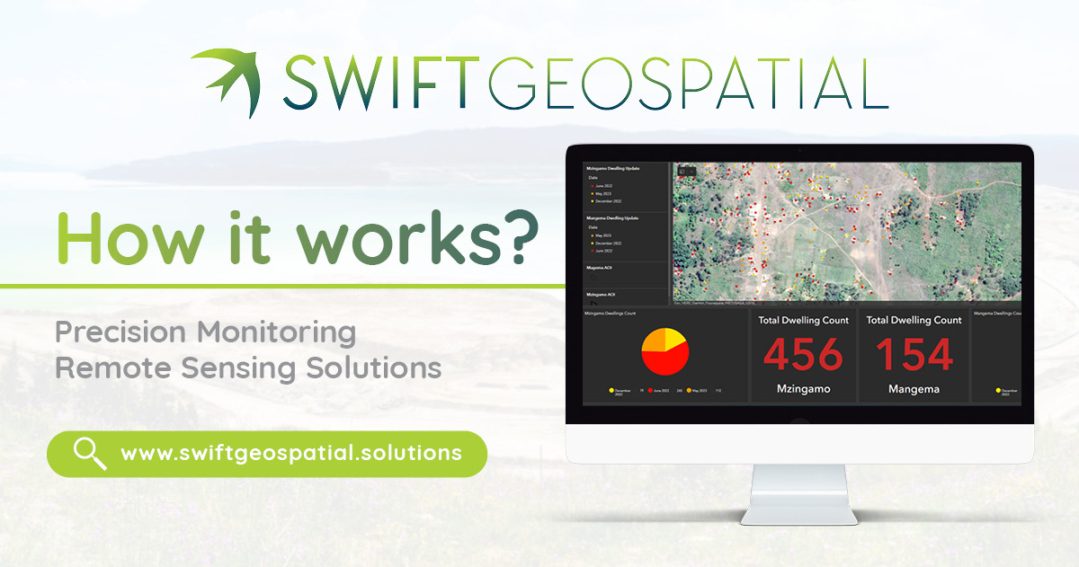
Data-Driven Decision Making with Easy-to-Use Dashboards
At the heart of our service offering is the ability to transform vast amounts of geospatial data into easy-to-understand insights. We know that not every mining professional has the time or technical background to sift through raw data. We use raw satellite imagery to perform the mentioned analysis for you. The output is then shown to you in the digestible format of our dashboards. That’s why Swift Geospatial provides intuitive, user-friendly dashboards that present critical data in a clear, concise manner. Whether it’s TSF monitoring, stockpile measurements, or environmental tracking, our dashboards offer a real-time overview of all key metrics, accessible from anywhere at any time.
This allows for quick decision-making and helps mining companies stay agile in a fast-moving industry. With Swift Geospatial as a partner, mining operators can ensure that they always have the latest data at their fingertips, driving informed decisions that improve efficiency and safety.
Why Mining Clients Trust Swift Geospatial
At Swift Geospatial, we understand that no two mining operations are the same and bespoke solutions are required. Our experienced team of remote sensing experts takes a personalized approach to each task, working closely with clients to develop tailored remote sensing solutions that will meet their unique operational and regulatory needs. Whether it’s a remote mine in the mountains, which can be difficult to monitor on foot, or an extensive operation in the desert, we provide scalable services that fit your specific situation.
Mining companies choose Swift Geospatial because we offer more than just data – we offer solutions that are useful in key decision making. Providing clients with actionable information to stay ahead of the competition. Our advanced monitoring systems not only provide critical insights into daily operations but also ensure that you remain compliant with ever-changing industry regulations.
In the fast paced business environment where actionable data is power, Swift Geospatial empowers mining clients to make smarter, faster, and more sustainable decisions. Our focus on precision, innovation, and client collaboration ensures that we are always at the forefront of the mining industry, helping our clients operate more efficiently while reducing their environmental impact.


